Hybrid Navigational Approach for the Catskills Off-trail Regime
(Another Summer Bushwhacking Adventure)

Old-schoolers insist on carrying maps. Paper maps.
I used to carry paper maps. Back in my Army Ranger days, some 40 years ago – always. Of course, that was before GPS. Since then -- not so much. In August 2021, I was thru-hiking the John Muir Trail, and I distinctly remember reaching into my pocket for the map, but it wasn’t there. I’d stopped at Woods Creek to filter water and placed the map on a rock to keep it from getting wet. This was two miles back. I was so upset when I realized I’d have to go back to retrieve it.
Today, I rarely carry paper maps, and never in the Catskill Mountains, which lie in New York’s Hudson Valley, an area I know intimately. Instead, I use technology. That’s not to say I’m ignorant of the risks. The more you stare at a compass needle or screen, the less you look around and think. David Barrie, a fellow of the Royal Institute of Navigation, describes GPS as one of the great achievements of modern times. But then he comments on what the technology is doing to us, now that we’ve become dependent: “Though we may not realize it, we are fast becoming navigational idiots.”
To counteract the slide towards idiocy, I sometimes practice “natural navigation,” which is the art of finding your way through the forest without using any navigational aids at all. This kind of exercise teaches you to pay attention, and it’s a lot of fun to do with friends. For safety’s sake, carry map, compass, and GPS in your pack, in case you get confused.
Lessons learned from natural navigation, plus experience from the days of map and compass work, have helped me evolve a hybrid approach to off-trail navigation, combining the benefits of technology with the practice of observation. The goal is to maximize the odds of reaching the destination, while managing cognitive load, and thus hopefully minimizing mistakes, confusion, extra miles, frustration, and other bad outcomes.
It’s important to be thoughtful when off trail. Especially in the Catskills, where the slopes are rugged and forests thick. Indeed, the terrain renders “the eye of little service,” as the nature writer John Burroughs wryly observed 150 years ago. He noted that people who ventured off trail often turned back, “baffled and bewildered.”
The other day I set out for a weekend adventure with an ambitious plan – to complete a circuit of the West Kill valley in the central Catskills, bagging as many as a dozen mountains. Tucked in the bottom of my 20-liter pack was a sleeping bag in case I needed to spend the night, and to save on weight only 1.5 liters of water.
In preparation for this outing, I’d used the popular AllTrails app on my laptop to plot a couple of different routes, then downloaded them onto my phone since there’s no cell coverage in the mountains. AllTrails has handy features for trip-planning, like mapping out the most efficient route on trails and tabulating distance and elevation gain automatically. Back in my Army days, we used protractors to plot each leg of the movement plan. To estimate distance on trails, we’d curl a bit of string along the route and then stretch it out against the legend. It was a cumbersome procedure. In any case, we didn’t typically follow trails, as that wasn’t considered tactically sound.
Packsaddle Mountain (3,100 feet)
I pulled into a grassy parking spot in the West Kill valley on a sunny morning in July. Took a casual glance at the AllTrails map, then shoved my phone in a trouser pocket, and started up Packsaddle Mountain. One of the lessons I’ve learned from natural navigation is what friends and I refer to as the “rule of up.” Unless there is some bizarre quirk to the topology, your feet will naturally take you straight uphill, since that’s easier than walking on a slant, and lead you to a summit.
This morning as I climbed, instead of staring at compass needle, paper map, or GPS screen, I was observing. Looking for the easiest “lines” – meaning places which offered more level footing and fewer obstacles – a zig one way to avoid some boulders – then a zag around a pile of fallen trees. I also sought out lines to avoid unfriendly plants, like the bands of stinging nettles now growing knee-high. Needles on the leaves and stems can irritate exposed skin. I was eager to avoid the plants, since I was hiking barefoot, which is my practice in the summer months.
I pulled out the phone for a map check, to make sure I was still on state land and hadn’t wandered onto private property. With a paper map, it’s hard to identify your location, unless you happen to be standing on a distinctive point. You could attempt to “triangulate” by identifying two visible landmarks, measuring compass heading to each of them, and then plotting the intersection of these lines on your paper map (hopefully it has gridlines so you can orient your protractor). In the thick forests of the Catskills, however, there’s rarely anything to see.
It was a nice morning. Not too hot. No biting flies. After a bit, my GPS watch beeped, indicating I’d gone one mile. I estimated I was moving at about a 1 mph pace, which turned out to be spot on – the display read “1:00:59.” The read out showed another 300 feet to climb, so I settled in for a few more minutes of steady effort and soon was standing at the top.
The climb was uneventful, the only surprise being the profusion of bindweed. On past hikes, I’d noticed the arrowhead-shaped leaves, tiny white flower buds, and long thin red tendrils crawling along the ground, looking for stems and saplings to climb. But here it covered the entire forest floor.
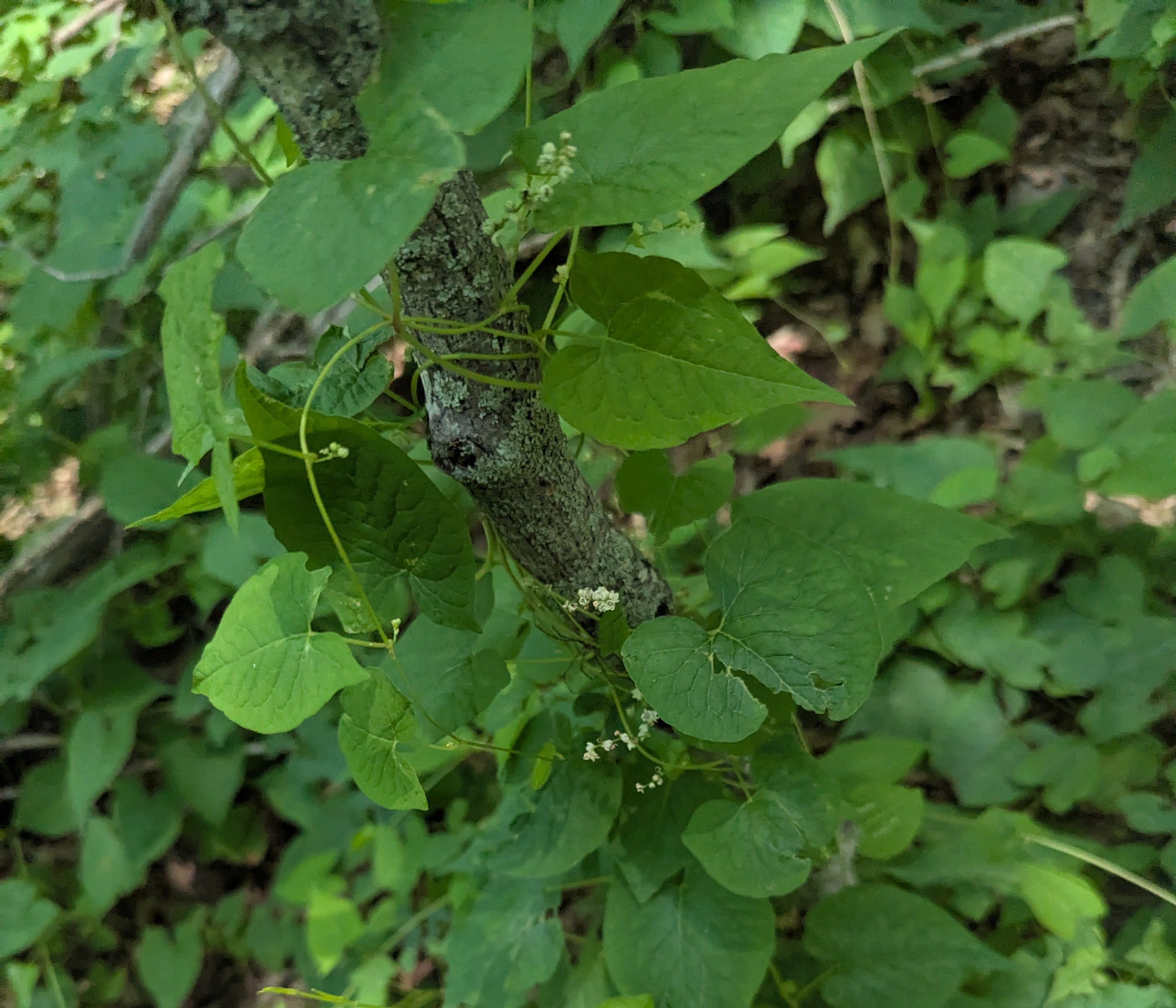
Bindweeed
Pine Island Mountain (3,146 feet)
The good news is that the rule of up works pretty well. I’d made it 2 miles through thick forest to the top of the mountain, without using map or compass, and taking only one or two glances at my phone. Unfortunately, there is no “rule of down.” From the top of a mountain, you have 360 degrees of freedom, which means the flexibility to wander downhill in practically any direction.
So now I opened a second navigational app on my phone, containing a high-quality digital map of the Catskills produced by the New York-New Jersey Trail Conference under the auspices of star cartographer, Jeremy Apgar, and drew a line on the screen from my current position to the saddle below Pine Island Mountain, my next objective. The display read 135 degrees, to which I added the 13-degree declination needed to convert the grid direction into a magnetic heading. I pulled out a plastic compass, dialed in 150 degrees (close enough), gave the wobbling needle a chance to settle down, and pointed it in the direction of movement. To the front -- a riot of vegetation. A wild mix of beech, birch, maple, and occasional mountain cherry trunks. And that surprising profusion of bindweed.
Back in my Army days, following a compass heading was the only way to keep on course when moving through thick forest. Back then, I was proficient at land navigation exercises (what civilians call orienteering), completing compass courses during the day and at a night and consistently finding my way to the control points. But in the Catskills, I’ve gradually fallen out of this practice. The problem is that when staring at the compass needle, or aiming for a tree trunk maybe 50 yards ahead (and trying not to confuse it with its neighbors), it’s hard to scan ahead for the easiest lines. Suddenly you look up and you’re caught in deadfall or standing beneath a cliff. So now I put away my compass and glanced at the sun, which was hanging in the south. Since I was moving east-southeast, my shadow lay to my left, which was all I needed to stay on course.
The descent into the saddle went well enough, although steep terrain in the Catskills can get trying. You step on the edge of a sandstone plate, hoping it won’t slide out from under you. Or you place a foot on a pile of leaves, being careful not to punch through into an ankle-busting hole. Off-trail in the Catskills is a complicated regime not only for navigation, but honestly just for walking. It sometimes feels more like climbing on a jungle gym.
I made it down into the saddle without issue, except at one point blundering through a band of stinging nettles. I gathered up some jewelweed and rubbed the leaves on my shins and the tops of my feet, and the sap cooled the irritation.
From here the climb up Pine Island was uneventful (rule of up again), except it took longer than expected. I stole a glance at the phone, saw I was on a false summit, with the true top being another quarter-mile away. Meanwhile, the bindweed was starting to get annoying. It had crawled into knee-high patches of evergreen wood fern, and this tangled mess hid the obstacles on the ground, forcing me to grope my way by feel, lest I trip on a hidden rock or log or step into an invisible hole.
My watch beeped again. This last mile had taken longer – nearly an hour and a half. Thanks to the heavy vegetation, my ambitious plan to circuit the valley was starting to seem questionable. At this pace, it would be well after dark before I’d reach the first water source.
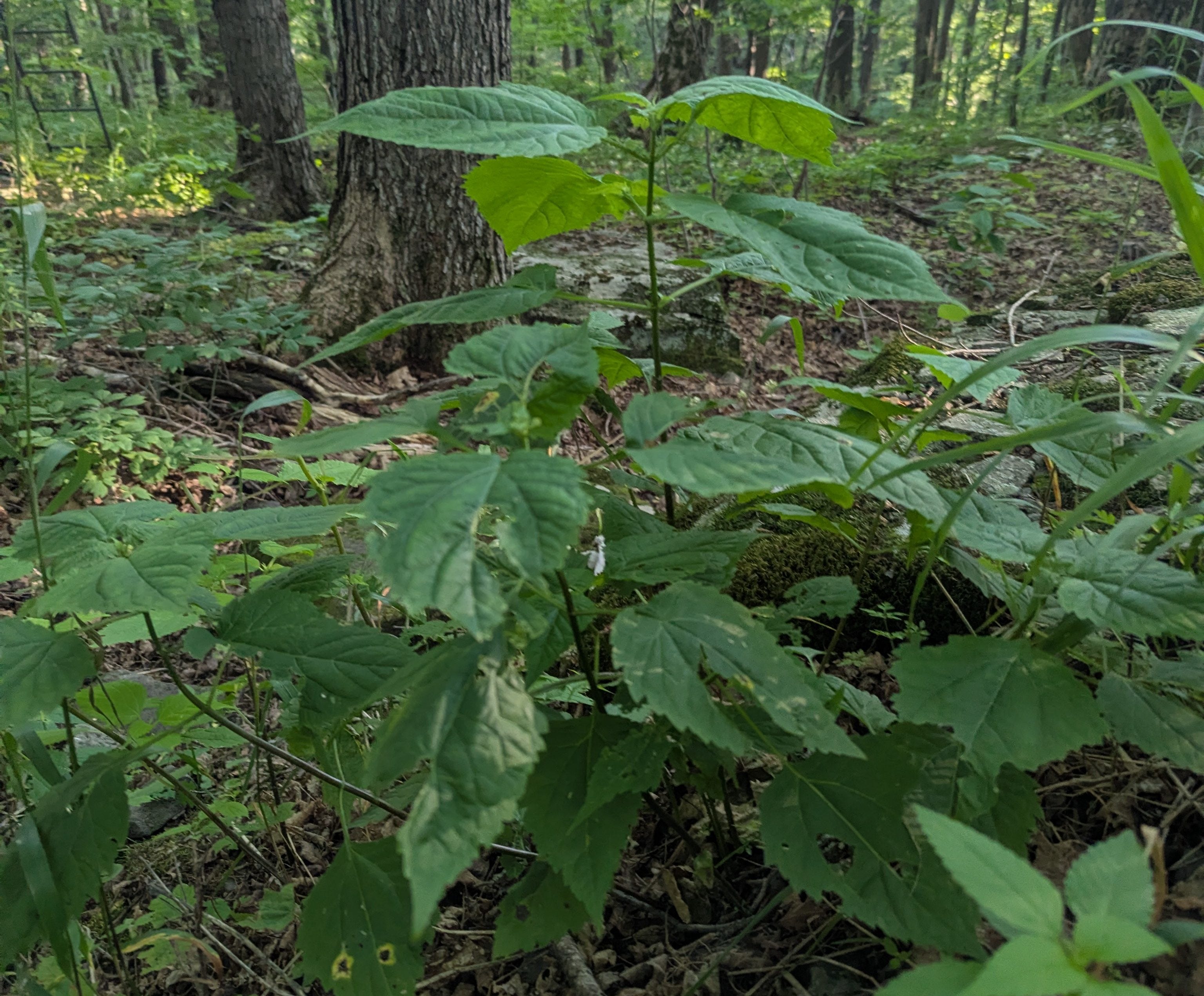
Stinging Nettle
Evergreen Mountain (3,379 feet)
I toyed with the idea of abandoning any further peaks and just getting out of here. But the next one, Evergreen Mountain, seemed so close. After deliberating for another moment, I decided to keep going, but there would be little tolerance for mistakes. After plotting an azimuth to the next saddle, I studied the map on my phone more carefully. The contour lines showed a narrow ridge curling down and to the right, whereas the saddle lay ever-so-slightly to the left.
I crept forward, scanning for drop-offs on either side, to keep me squarely on the crest. The slopes were just barely perceptible through the welter of foliage. After a few minutes, I paused, turned my head to he left, and looked up -- and there was Evergreen Mountain, staring down at me. Actually, it was only through small gaps in the forest canopy that I could make out its hulking shape. Gaps just a few leaves wide, revealing glimpses of the mountain’s shoulders, diagonal lines of distant treetops gleaming slate green in the distance.
On the descent into the saddle, there were more nettles waiting for me, and once again I took a moment to rub my feet and shins with jewel weed, giving them a slight green tint which complimented the light brown swirls of dust and pollen already accumulated.
After nearly 5 miles of barefoot bushwhacking in jungle-like conditions, my water was running low, and my patience was wearing thin. There is type I fun, like going to the movies. And type II fun, such as running ultramarathons. I don’t know if there is such a thing as type III fun, but if so, summertime bushwhacking in the Catskills might qualify.
Hasard Lee is a F-16 fighter pilot who’s written about the art of clear thinking, and one of his key points, which seems germane to hikers, runners, and mountain climbers, is the importance of managing cognitive load. When stress increases, intelligence declines. In other words, if you let your mind get overwhelmed, it becomes easy to make mistakes.
While bushwhacking is not as risky as piloting an advanced fighter platform at supersonic speeds, bad outcomes are still possible. Navigational errors can waste a lot of time and effort, leading to frustration and fatigue, which compounds the risk of further mistakes. There may be no cell coverage. No way to call for help. If you were to become injured and immobile, it would be a challenging task for SAR teams to find you without air-scent dogs or extensive grid operations.
To manage my mental state, I stopped and breathed deeply. Took a gulp of my limited stock of remaining water. Reminded myself that the rule of up would surely get me to the top of Evergreen.
When I finally reached the summit ledge, I found a tumble of boulders covered in waist-high ferns tangled with more bindweed. There was a veritable ocean of bindweed. The thin red tendrils were snagging my ankles and getting caught between my toes, until I felt like I could hardly move.
With all my years of Catskills hiking, how was it that I’d never encountered so much bindweed?[i]
I’d been on Evergreen once before, several years ago, but it was during early spring, and an inch or two of snow made for an easy climb in running shoes. I’d admired the views south toward Sherrill and North Dome Mountains and noticed a hunting stand bolted to a tree.
Today, when I reached the top, there was no view. Nothing but curtains of brilliant sunlit green. I thought of the hunting stand I’d seen on the prior trip, looked up, and there it was right in front of me, bolted to a tree.
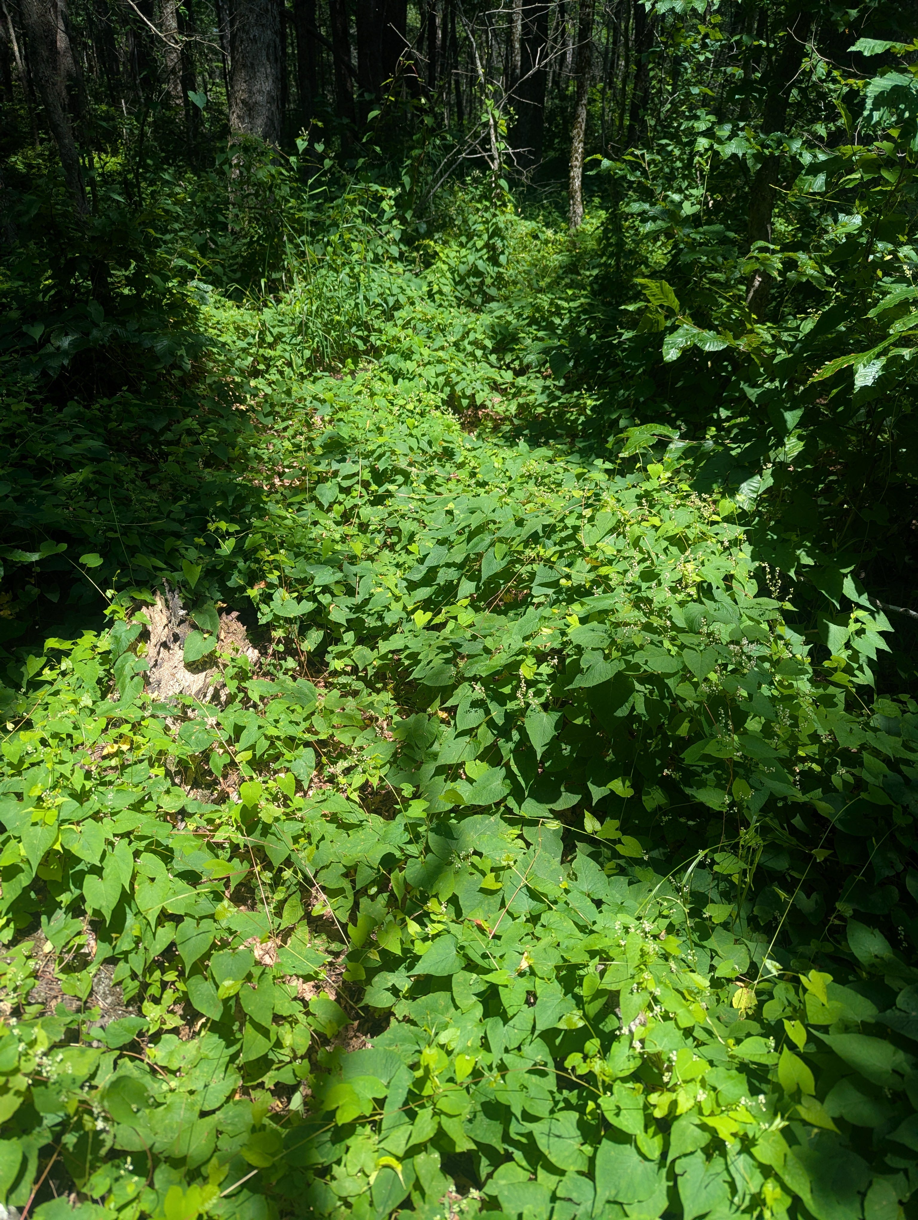
Summit Scene
The Descent
It was time to bring this adventure to a safe conclusion. I measured an azimuth back down into the valley. Noticed the sun hanging above the ridge, out of the corner of my right eye.
I kept the sun to my right during the descent, which was steep and nasty. There were tilting rocks. Holes beneath the leaves. Abundant fallen trees. Beech saplings barring the way with long whip-like branches hanging at chest and face level. Conscious of the risk of error while descending, I checked the map frequently, and with each check, the dot that represented my location moved ever so slightly, but it stuck right on top of the plotted line, at least at first.
The shadows began to lengthen. The next map check showed I’d slipped off the crest and begun to slide down the mountain’s flank. If I didn’t get back on course, I might pop out in the valley in the middle of someone’s back yard, which the inhabitants might not appreciate.
To get back on course, I stuck to a level contour. Eventually the ridge dropped down to meet me, and I emerged into the last of the sunlight. But the descent remained steep and vexing. At one point I placed a hand on an old trunk lying prostrate on the ground – only to punch straight through the whole rotten core and tumble to the ground.
Two miles down seemed to take forever. Nautical twilight fell. I pulled out my headlamp, checked the light, and when it didn’t work replaced the batteries. Phone showed 1% power remaining. I plugged in an extra battery which was freshly charged. The map showed I was nearly to the valley -- then I caught the muffled whine of tires. I stuffed phone, charger, and headlamp into a trousers pocket and zipped it shut. No point in making mistakes so close to the end, I thought to myself, as I double-checked the zipper.
To the front, dense thickets guarding the banks of a creek. The ground underfoot was turning wet. I trudged upon dewberry brambles sprouting in the mud, which prickled underfoot. Passed tall stalks of swamp thistle and clumps of wild parsnip. Entered a small forest of multiflora rose, a non-native species which was introduced in the 19th century for livestock containment, as its dense thorny growth creates impenetrable barriers. Then it started spreading invasively. Everywhere. I found a deer trail tunneling through the tangles, but then I got stuck in a mess of thorny deadfall.
One of the safety benefits of going barefoot, is that if the going gets tough, you can reach into your pack and pull out shoes, which lets you suddenly move twice as fast or faster. With soles now shielded by a quarter inch of rubber, I stomped aggressively through the mess until a long stem with thorns the size of dragon’s teeth snared me around the ankle. My mental RPMs redlined, and I started shouting in alarm. As if someone might hear me and come to my rescue with a chainsaw. Or at least some pruning shears.
By the time I made it onto the road, I’d taken a vow to never again undertake a Catskill bushwhack in the summer, when the vegetation is out of control.
I shambled along the pavement as Sherrill and North Dome loomed in the south, shining with subtle alpenglow, while the half-moon hung above them. Yellow hop clover and birds foot trefoil tinged the roadside grass, while tiger lilies were blooming orange. Across the valley, distant lights and sounds of children laughing. I started reconsidering that vow.
Compared to flying, moving off-trail in the summer Catskills is a pretty slow affair. But I suspect both regimes require a similar mindset. A combination of technology and judgment. The ability to pay attention, solve problems, manage mental bandwidth, avoid excessive stress, stay in the flow state to the extent possible. Skills which, incidentally, are necessary for much of what we do at work and home and in many other parts of life. Which is why I find barefoot bushwhacking to be a useful training modality for practicing equanimity and poise.
The hybrid navigational approach I utilize works well for me in the Catskills, and even when traveling I employ a similar mix of technology and observation skills. Which is why I rarely carry paper maps. But in the spirit of full disclosure -- when operating in unfamiliar places, I generally stick to trails.
[i] From my observations, it seems that bindweed prefers south-facing slopes with relatively open forests which get more sun. Upon reviewing my training logs and maps, it would appear that many of the high peak bushwhacks in the Catskills which I’d completed in recent years are situated on north-facing slopes, or high up in relic boreal thickets with abundant spruce, fir, and hobblebush, and too much shade for bindweed.
Chasing the Grid is available for pre-order on Amazon!